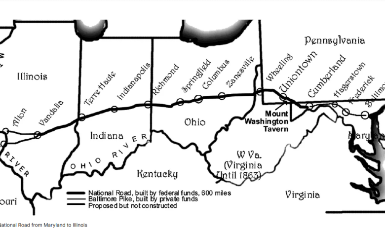
Long before interstates and highway systems, America’s first federally funded road began as a rugged path carved through the Allegheny Mountains. In this episode of Pave It Black, National Park Service Site Manager Brian Reedy joins the podcast to share the remarkable history of the National Road, from its origins in the French and Indian War to its role in shaping American infrastructure, commerce, and westward expansion. Reedy manages Fort Necessity National Battlefield and Friendship Hill National Historic Site in southwestern Pennsylvania, giving him firsthand insight into the people, places, and engineering that built the nation’s first great highway.
Reedy explains how taverns, stagecoach stops, and wagoner stands shaped travel and commerce along the route, and how the road’s fortunes rose and fell with the arrival of railroads, bicycles, and eventually automobiles. The discussion also highlights the National Road’s lasting legacy as the foundation for the US highway numbering system still used today.
Here’s a sneak peek into this week’s conversation but be sure to tune in to the full episode for all the insights. You can listen wherever you get your podcasts.
BW: Brian, I’m curious if you could start us off and give us a little more detail about what the National Road is, why it was built, and maybe the purpose of that facility.
And I say road, but it was basically paths, traders’ paths, migration trails, that American Indians would have been using, as well as British traders. It’s a vast network that really hadn’t been consolidated until the 1750s. A group of land investors called the Ohio Company began to blaze out a specific trail connecting the Potomac River with the Ohio, and Christopher Gist is the gentleman who did that.
BR: The National Road’s origins actually begin in the 18th century, with the French and Indian War period. There was a great need to expand the 13 British colonies to the Ohio River Valley, which today we’d call Pittsburgh, Pennsylvania. They called it the Forks of the Ohio. So the rush was on to do that. From the north, the French, who had established today what we call Canada, New France, were interested in blocking any British advance into the Ohio River Valley.
The French had a slight advantage. They had interior waterways, so they could easily navigate large rivers like the Allegheny and the Ohio, down to the Mississippi, all the way to the Port of New Orleans. For the British, there were no navigable rivers through the Allegheny Mountains, so they had to rely on a road system.